
The 1906 Meishan-Chiayi Earthquake : A Seismic Disaster under Japanese Colonial Rule
Published:: 2026-03-02
Author:: William Favre
Topics:: [Taiwan] [Disaster] [Humanitarian] [Colonialism - Imperialism ] [Japan] [Environment] [Earthquakes]
[1] Jonathan Clements, Rebel Island: The incredible history of Taiwan, Scribe Publications, Brunswick, p. 136 (epub).
[2] International Seismological Centre (2025), On-line Event Bibliography, View source, (event code: MEISHAN1906)
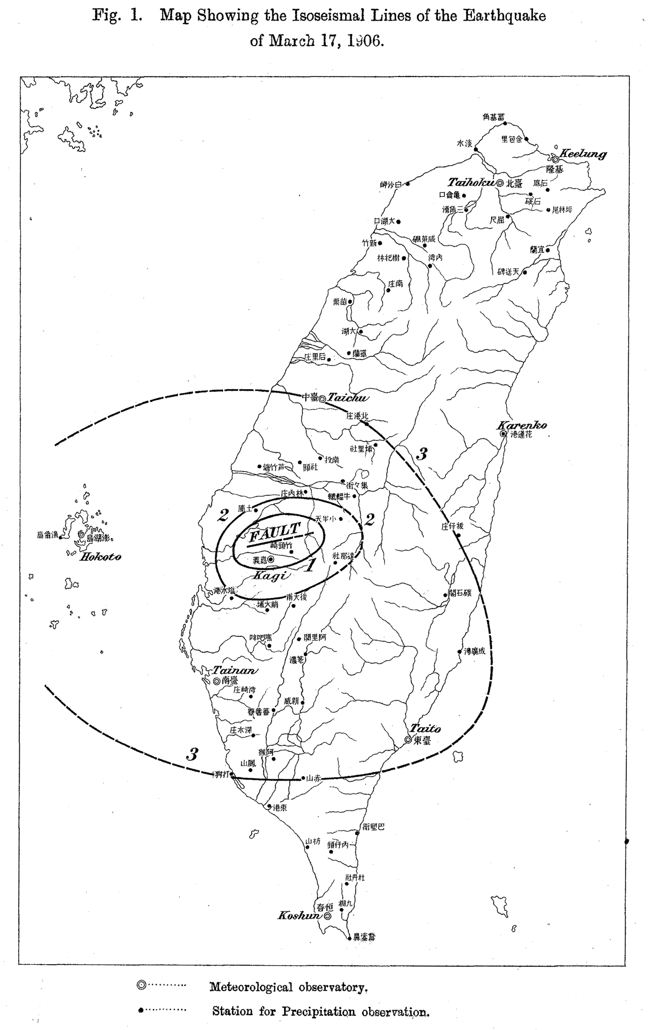
[fig 1] Omori Fusakichi, Map of the isoseismic lines of the 1906 Meishan Earthquake, 1907, source: “Preliminary Note of the Formosa Earthquake of March 17, 1906 (Published 1907)”, in: Bulletin of the Imperial Earthquake Investigation Committee Bulletin of the Imperial Earthquake Investigation Committee, vol. 1, Num. 2, pp. 53-69, 1907-04-01.
Introduction: Setting the stage
We are on March 17th 1906, in the central part of Taiwan, more exactly in the village of Meishan (“Plum Mountain”) in the modern county of Chiayi. The island was conquered about 10 years prior by the Japanese military after its victory during the Sino-Japanese war of 1894-1895, as spoil of war. The invasion and colonial conquest of this crossroad of Asia weren’t done without trouble and a fierce resistance movement opposed the Japanese forces, mostly in the mountainous areas of the island[1]. After the temporary First Republic of Formosa was crushed by the Japanese, the process of incorporation to the realm began. By 1906, the Japanese colonizers succeeded in integrating and stabilizing their grip on the island.
The tremor hit early in the morning at 06:43 am, explaining partly the deadliness of that peculiar earthquake among other reasons. The magnitude of the earthquake was quite powerful with an intensity 6.8 on the Richter scale. The epicenter of the earthquake was situated at a depth of 6 km, which is quite shallow for a tremor[2]. Its shallowness made it only more lethal. The shallower the core is, the stronger the impact. The inhabitants of the rural towns of Meishan and Chiayi were surely brutally woken up by the brutal shockwaves. Tragically for a large number of the inhabitants, their shelter became in an instant a deathtrap when the houses collapsed.
The tremor hit early in the morning at 06:43 am, explaining partly the deadliness of that peculiar earthquake among other reasons. The magnitude of the earthquake was quite powerful with an intensity 6.8 on the Richter scale. The epicenter of the earthquake was situated at a depth of 6 km, which is quite shallow for a tremor[2]. Its shallowness made it only more lethal. The shallower the core is, the stronger the impact. The inhabitants of the rural towns of Meishan and Chiayi were surely brutally woken up by the brutal shockwaves. Tragically for a large number of the inhabitants, their shelter became in an instant a deathtrap when the houses collapsed.
[3] Fusakichi, Omori, “Preliminary Note of the Formosa Earthquake of March 17, 1906”, in: Bulletin of the Imperial Earthquake Investigation Committee, Vol. 1, Num. 2, pp. 53-69.
[4] Ye Yong-tian, Chen Guo-chang, Xiao Wen-qi & Central Weather Bureau. (2001). 地震-地理資訊系統資料庫之規劃與設計 (III), View source.
[5] Government Information Office, Taiwan Yearbook 2005, p. 23.
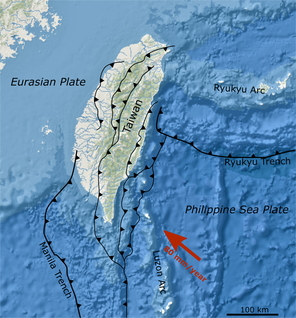
[fig 2] Mikenorton, Bathymetric map of the area around Taiwan, taken from the National Centers for Environmental Information Bathymetric Data Viewer, with main tectonic boundaries modified after Molli & Malavielle (2010), 20.03.2022, Wikimedia, View source.
The shock was so intense that we can even see traces of the disaster today. Creating the Meishan trench, the ground subsided on 25 kilometers, on the whole width of the Chiayi county. Some aftershocks still shook the territory for the rest of the day, slowing down the relief efforts on the most urgent moments for the rescuers[3].
Beyond the casualty of 1 '266 victims and 2' 476 injured inhabitants, the region observed 7 '284 destroyed houses and 30' 021 partially destroyed ones. In other words, the settlements in the Chiayi area were almost entirely wiped out[4].
This dramatic earthquake is grounded in a long history of seismicity on the island. Taiwan is part of what we call the Pacific Belt of Fire, an area corresponding to the rim of the Pacific plate colliding with the other plates. The consequence of this peculiar geologic disposition is the high seismic and volcanic activity of the area, a significant number of earthquakes and eruptions occurring on the Pacific Ring of Fire. In Taiwan, most of the seismic activity of Taiwan comes from two zones: a zone crossing vertically the coastal plain of western Taiwan, bisecting Chiayi and another on the eastern coast, a fault beginning in the region of Hualien in the north to Taitung in the south. These two major danger zones are in fact the superposition of 42 active seismic faults riddling the island and areas with relatively high population density or zones with peculiar geomorphological make-up. For Taiwan, the conjunction of the Pacific, Philippine Sea and Eurasiatic plates create the ideal set-up for a high seismic activity of high intensity[5].
[6] Liao, Yi-Wun & Ma, Kuo‐Fong & Hsieh, Ming-Che & Cheng, Shi‐Nan & Kuo-Chen, Hao & Chang, Chung‐Pai. (2018). Resolving the 1906 Mw 7.1 Meishan, Taiwan, Earthquake from Historical Seismic Records. Seismological Research Letters. 89. 10.1785/0220170285; Nan-Wei Wu, Architectonics of Seismicity: Building and colonial culture in Japan and Taiwan from the Meiji Period to the Second World War (PhD), University of Edinburgh, 2012; Alsford, N.J.P., “The 1935 Hsinchu-Taichung Earthquake: Natural Disas
[7] Gregory Clancey, Earthquake Nation. The cultural politics of Japanese seismicity, 1868-1930 University of California Press, Berkeley, 2006.
[8] Kim Boumsoung, “Seismicity Within and Beyond the Empire: Japanese Seismological Investigation in Taiwan and Its Global Deployment, 1895-1909”, in: East Asian Science Technology and Society-An International Journal, Vol. 1, Num. 2, 2007, pp. 153-165.
[9] Kim Boumsoung, op. cit., p. 155.
[10] Reginald Kann, « Formose, première colonie du Japon », in: Le Tour du monde : nouveau journal des voyages, Num. 51, 21.12.1907, pp. 601-623.
[11] Guillaume Blanc, La nature de l’historien. Par le haut, par le bas, CNRS Editions, Paris, 2025, pp. 69-71.
[12] Guillaume Blanc, ibid., pp. 16-17.
[13] Taiwan Government General, Ministry of Social Affairs, General Affairs Bureau (Taiwan Sōtokufu Minseibu Sōmukyoku), Investigation on the Earthquake in Chiayi’s Region (Kagi chihō shinsai shi), Taiwan Nichi Nichi Shimbun, Taipei, 1907.
[14] Taiwan Nichi Nichi Shimbun, True Photographical Report on the Southern Taiwan Earthquake (Nanbu Taiwan shinsai shashin jō), Taiwan Nichi Nichi Shimbun, Taipei, 1906.
[15] Being a researcher living in Europe and still in the process of learning Mandarin.
[16] Robert Thomas Tierney, Tropics of Savagery. The Culture of Japanese Empire in Comparative Frame, University of California Press, Berkeley, 2010, pp. 11-12.
Thanks to its historical importance, this disaster already met some visibility in academia. The earthquake met the most attention in the Chinese and in the Japanese language literature. The most detailed studies were locally written by Taiwanese historians or by seismologists seeking to retrace the technical details of the disaster. Historians of urbanisme/ architecture have turned their attention to the city of Chiayi to study the reconstruction project of the town by the Japanese colonizers after the disaster[6]. This particular case allowed them to take a closer look at the manner how urban centers can rebuild from severe environmental damages and urbanism in colonial context, especially under Japanese rule. Colonial Taiwan could then be compared to Korea, Sakhalin or the Kwantung Peninsula and later Manchuria[7]. In Japanese literature, we may cite the literature on the history of science, more specifically the history of seismology. The Chiayi earthquake, notably under the pen of Kim Boumsoung, is remembered as an example of colonial science[8]. His main argument is that the most prominent Japanese seismologist of the time, Ōmori Fusakichi, was dispatched to Chiayi a few weeks after the earthquake. After the study of the collapsed buildings in the Chiayi area, Ōmori concluded that those weren’t structurally sound enough, implying that the locals didn’t know how to build stable architecture in an unstable environment[9]. It shows that seismology didn’t evolve separately from society and was engulfed in colonialism like other disciplines, even being mobilized to justify colonization.
In Western languages, the literature is scarcer, being relatively restrained on the subject and has the tendency to refer to the Chinese or Japanese literature concerning the event. The only existing literature is mainly contemporary sources coming from two personalities: the American missionary William Campbell and the French war reporter Réginald Kann, whose travel of 1906 there survives in Dutch and French[10].
For secondary literature, we might mention the work of Guillaume Blanc, a French environmental historian. Blanc, through his writings, defines the environment as a balance of power between different human actors and non-human actors/ factors. This more interactional approach seemed pretty adapted for the context of the 1906 Meishan earthquake since multiple actors and forces struggled around the stake of the space stricken by the earthquake, through a diversity of conflicting intentions[11]. In our case, the Japanese, Chinese-speaking and Hoanya/Tsou actors. Moreover, such a definition based on power allows an interesting ontological overlap over the definition of racism: a domination of one social group on another based on a fictional biological reality, a naturalized form of a class domination[12]. Hence, both interactions have power based on a non-human factor as a stake.
Concerning the primary sources, the main sources are in Japanese and in Chinese as well. On the Japanese side, the main producers are the colonial and central authorities, followed by press articles emanating from the national titles and scientific articles produced by actors like Ōmori. Maps and photography were produced as well and tended to complement the other types of sources found in archival reserves. One of the most direct sources on the reaction of the colonial authorities is contained in the report made by the General Bureau of the Government-General of Taiwan on the earthquake. The “Report on the Earthquake of the Chiayi Region” (Kagi chihō shinsai shi) recounts in a chronological and thematic order the disaster and its aftermath[13]. This very report is completed by diverse archival documents located mostly in Taiwan but for some in Japan too. In Chinese, the sources come from local gazettes and titles and regional accounts could be found for documenting the earthquake from the inside. As supplementary archives, we may cite the “True Photographical Report on the Southern Taiwan Earthquake”, whose main interest lies in diverse photographs on the event[14].
Being aware of the colonial biases in the primary sources is here crucial as well. One of the principal filters found during this investigation was twofold: the first one being the ubiquity of Japanese sources or archives retransmitting the Japanese narrative of the events and the second one being the digital filter of the selected documents “important enough” to get through the process of digitization. The second filter is proper to the author’s situation, researching from abroad and being an outsider to the realities of the local Taiwanese society[15]. What are then the possible solutions to decolonize our gaze from the events ? Beyond a solid knowledge of the Japanese colonial period of Taiwan, one must be even more vigilant not to comply with a narrative developed by the Japanese colonial authorities of the time and the biases coming along. One of the most important narrative elements of the colonial discourse is the “civilizing mission” that was used as an argument to occupy the island militarily[16]. The region of Chiayi, as we will later in more details, is in Taiwanese history an outpost of colonial powers, for example being the first settlement of the Dutch during their short colonial encroachment on the island. As a supplementary challenge, Taiwan became under Japanese rule a double layered colonial society, with on one side Chinese speaking settlers mainly from the provinces of Fujian and Zhejiang; on the other side, the Taiwanese aborigines populations, the Tsou/Hoanya and Bunun people being the nearest to the Chiayi-Alishan area. It is thus a tripartite society with complex interactions we may explore in the next chapters.
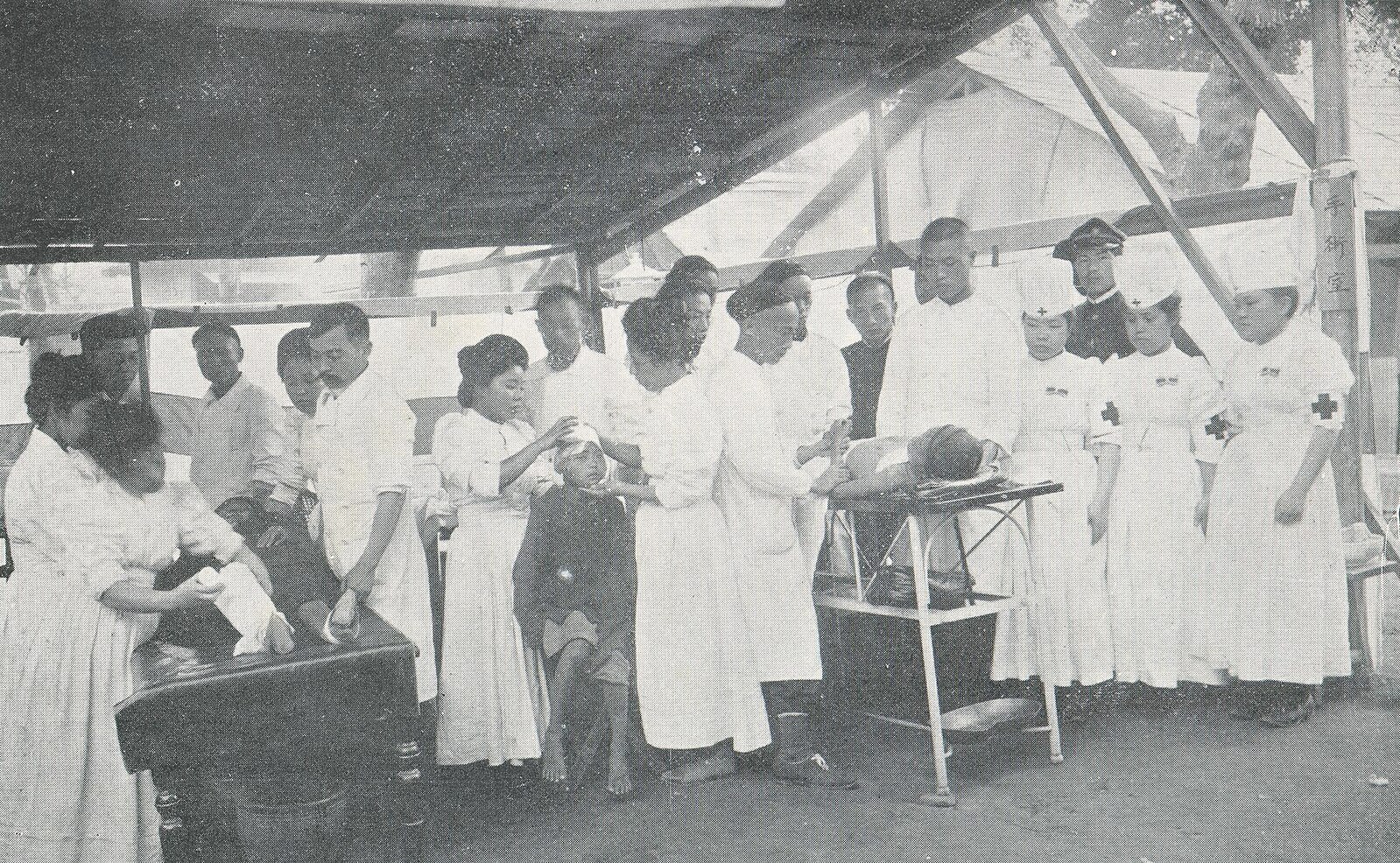
[fig 3] Unknown Author, 收容所內手術室 (Shuyosho naishujutsu shitsu/ Field hospital after the Great Kagi earthquake 1906), source: Taiwan Nichi Nichi Shimbun, True Photographical Report on the Southern Taiwan Earthquake ( Nanbu Taiwan shinsai shashinjō 南部臺灣震災寫真帖), Taipei, Taiwan Nichi Nichi Shinbun, 1906, p. 46.
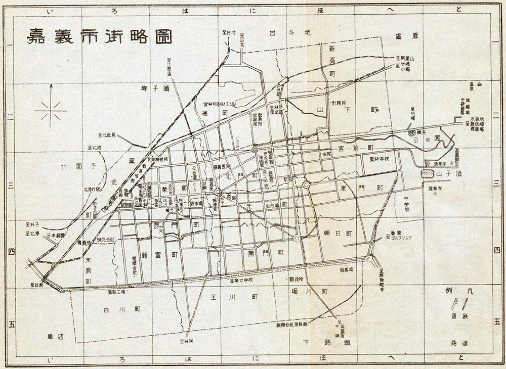
[17] Taiwan Government General Kōbun Ruisan, Street Map of Kagi (Kagi Shigai Shinsokuzu), Taiwan Government General, Taipei, 1932, View source, consulted on the 10.01.2026.
[18] Taiwan Government General, Ministry of Social Affairs, General Affairs Bureau (Taiwan Sōtokufu Minseibu Sōmukyoku), Investigation on the Earthquake in Chiayi’s Region (Kagi chihō shinsai shi), Taiwan Nichi Nichi Shimbun, Taipei, 1907, pp. 146-149.
Part 1: the Immediate Aftermath of the Earthquake
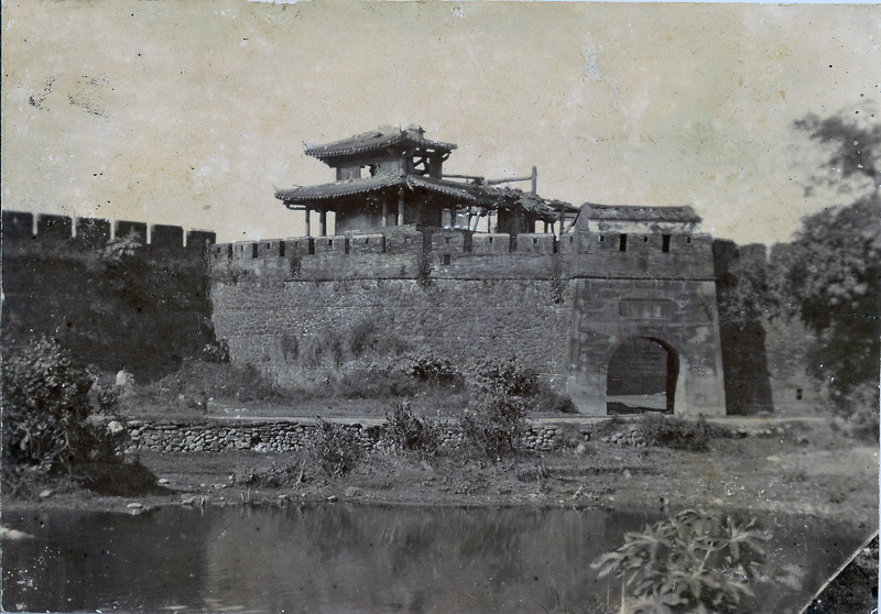
Before studying the reaction to the earthquake and the subsequent relief efforts, we must take a look at the terrain where those efforts were deployed and the gravity of the damages, particularly to Chiayi city proper. Chiayi (jp.: Kagi) is an important secondary center of the island, then under the jurisdiction of the Tainan prefecture (Tainan-ken). Its historical center was contained by a wall, through which were opened five gates[17]. The demographic growth of Chiayi could not be contained and saw the development of outer districts as well, on its major axes. The whole city has been damaged at different levels by the tremors. The final report states that 236 houses were totally collapsed and 332 partially collapsed and more than 2500 presenting light damages.
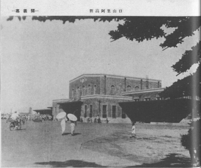
One important feature is that Chiayi mainly spreads on a West-East axis and that the only train station in proximity to the city is in its outskirts. The train line is on a North-South axis deserving the neighboring cities such as Tainan. The railways between Chiayi and Douliu have been damaged to the point of rendering the connection impossible. However, the main line between Tainan and Chiayi seemed to have sustained less damage[18]. This information is crucial in the extent that this line allowed for relief and aid coming from major centers of the island to flow into the stricken area. Plus, the walled city formed at the same time a protection at time of peace but could rapidly become a barrier in case of natural disaster.
One important feature is that Chiayi mainly spreads on a West-East axis and that the only train station in proximity to the city is in its outskirts. The train line is on a North-South axis deserving the neighboring cities such as Tainan. The railways between Chiayi and Douliu have been damaged to the point of rendering the connection impossible. However, the main line between Tainan and Chiayi seemed to have sustained less damage[18]. This information is crucial in the extent that this line allowed for relief and aid coming from major centers of the island to flow into the stricken area. Plus, the walled city formed at the same time a protection at time of peace but could rapidly become a barrier in case of natural disaster.
[fig 4] Japan Travel Association Taiwan section (Nihon Ryokō kyokkai Taiwan Shibu/ 日本旅行協會臺灣支部), Taiwan Railways Kagi Station, 1939 (1939-nian Taitie Chiayi zha/1939年臺鐵嘉義站), 30.01.1939, source: Taiwan Railways Travel Presentation, Showa year 14 edition (Taiwan Testsudo Ryoko Annai Showa 14nen pan) /《臺灣鐵道旅行案內》 昭和十四年版, 1940.
[19] William Favre, L’État de Meiji et le tsunami du Sanriku de 1896. Adaptation et gestion d'une catastrophe périphérique (Master dissertation), EHESS, Paris, 2021, pp. 12-18.
[20] Wei-Hsin Chen, “ Rescue and Reconstruction Operations of the 1906 Chiayi Earthquake”, in: Zhong Chen Lishi Xuekan, Vol. 16, 2013, pp. 109-148, pp. 128-137.
[21] Nanako Reza, Aaron Opdyke, Chiho Ochiai, “ Disrupted sense of place and infrastructure reconstruction after the Great East Japan Earthquake and Tsunami ”, in: Progress in Disaster Science, Vol. 22, 2024, 100322, ISSN 2590-0617, View source.
[22] Wei-Hsin Chen, “Rescue and Reconstruction Operations of the 1906 Chiayi Earthquake”, in: Zhong Chen Lishi Xuekan, Vol. 16, 2013, pp. 109-148; Beaussart, Grégory, Vivre avec les aléas « naturels », tome I, Anne Bouchy (dir.), Université Jean-Jaurès, Toulouse, 2017, pp. 17-30.
[23] Taiwan Government General, Ministry of Social Affairs, General Affairs Bureau (Taiwan Sōtokufu Minseibu Sōmukyoku), op. cit., 1907, pp. 375-391.
The situation following the earthquake is characterized by the Japanese term fukkyū or “return to the former state” of things, before the disaster. This contains, in the representations of the risk and disasters prevention milieux a more philosophical meaning with the restoration of the previous state of things, or normality. It is during this phase that the emergency is at its highest, depending on the gravity of the damages sustained by stricken communities[19]. The main task of those coping with the aftermath will be to restore the damaged infrastructures or lifelines that allow the flow of people, goods and information. Another task is of course to take care of people trapped in rubles or hurt by the effects of the disaster[20]. Generally, persons trapped under rubles do not survive beyond three days after their entrapment due to dehydration.
By “normality” in the case of an earthquake, we mean the return of a certain equilibrium that can be seen as material and social in nature. An earthquake represents a sudden rupture of a perceived social and economical order in the most stricken areas. In addition to this anthropological dimension, the material dimension comes from the destruction of the physical infrastructure allowing the sustenance of the communities in question[21]. The “return” to this normality would depend then on the communities’ own definition and on the exterior definition based on its materiality, if the stricken areas recovered for the most part (reconnection of the lifelines, reconstruction of the majority of the damaged built environment). Depending on the studied areas, the markers indicating the return to this equilibrium may differ. For the Taiwanese case under Japanese occupation, those social markers are the return of the stricken under the full control of the Japanese administration, the reestablishment of regular markets and the restoration of the local social order within the Chinese-speaking communities[22].
Concretely on the terrain, the measures taken by community leaders and by Japanese authorities were deployed in three steps for this “emergency regime”: 1. giving the alert and the mobilization of the available relief staff and aid resources 2. arriving in the stricken districts and providing aid, relief and shelter to the victims 3. stabilizing the crisis situation by progressively restoring the lifelines before consolidating them[23]. This aid and relief was as much medical than financial or even material. In the case of Chiayi, the efficiency of the Japanese authorities for rescue and restoration efforts were crucial. Being a recently annexed territory, the earthquake was a trial moment, putting the legitimacy of the colonial government to administrate and rule on those very communities.
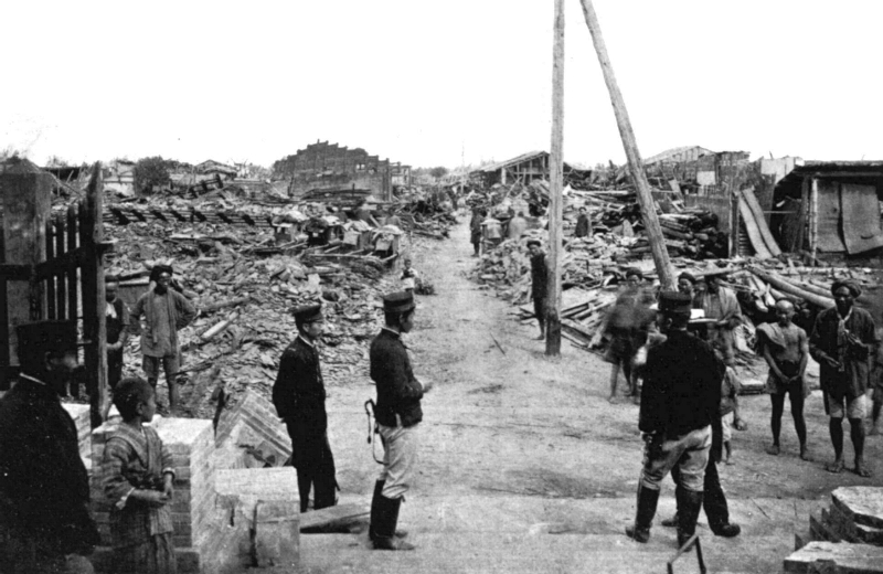
[fig 5] Unknown author, Aftermath of the 1906 Meishan Earthquake in Shinkō (Xingang), 1906, source: Taiwan Nichi Nichi Shimbun, True Photographical Report on the Southern Taiwan Earthquake ( Nanbu Taiwan shinsai shashinjō 南部臺灣震災寫真帖), Taipei, Taiwan Nichi Nichi Shinbun, 1906, p. 73.
[24] Taiwan Gouvernment General, Taiwan Gouvernment General Documents (Taiwan Sōtokufu Kōbun Ruisan), Vol. 4, inv. 04885, 1906, Institute of Taiwan History Archives, Taipei.
[25] Liao Ping-Hui, David Der-Wei Wang (ed.), Taiwan Under Japanese Colonial Rule 1895-1945. History, Culture, Memory, Columbia University Press, New York, 2006, pp. 97-99.
How was the governmental response organized ? The reaction to the earthquake was organized mainly on the government-general level, even though a few measures were taken up to the imperial level, from Tokyo. The decisions taken by the central government were mainly related to assistance concerning relief or the measures to be taken by the government-general office in Taipei, before passing down the hierarchical ladder to the local level, once the alert was transferred. The news of an earthquake in the Chiayi area was conveyed by telegraph transferring the alert, if the network wasn’t too much damaged[24].
The immediate aftermath of the earthquake in Chiayi county was taken in charge by the local authorities, built upon the hokō system or Baojia system where village heads would preside over a limited area. The Japanese colonial government recycled this system implemented during the Qing era to their own advantage, after having observed the limits of armed control[25]. The Japanese administration stacked itself up on this traditional political system, until creating a two-headed authority at the communal level. The hokō system would monopolize two important competences in the few weeks succeeding the earthquake: law enforcement and military might organized under the form of local militias.
The immediate aftermath of the earthquake in Chiayi county was taken in charge by the local authorities, built upon the hokō system or Baojia system where village heads would preside over a limited area. The Japanese colonial government recycled this system implemented during the Qing era to their own advantage, after having observed the limits of armed control[25]. The Japanese administration stacked itself up on this traditional political system, until creating a two-headed authority at the communal level. The hokō system would monopolize two important competences in the few weeks succeeding the earthquake: law enforcement and military might organized under the form of local militias.
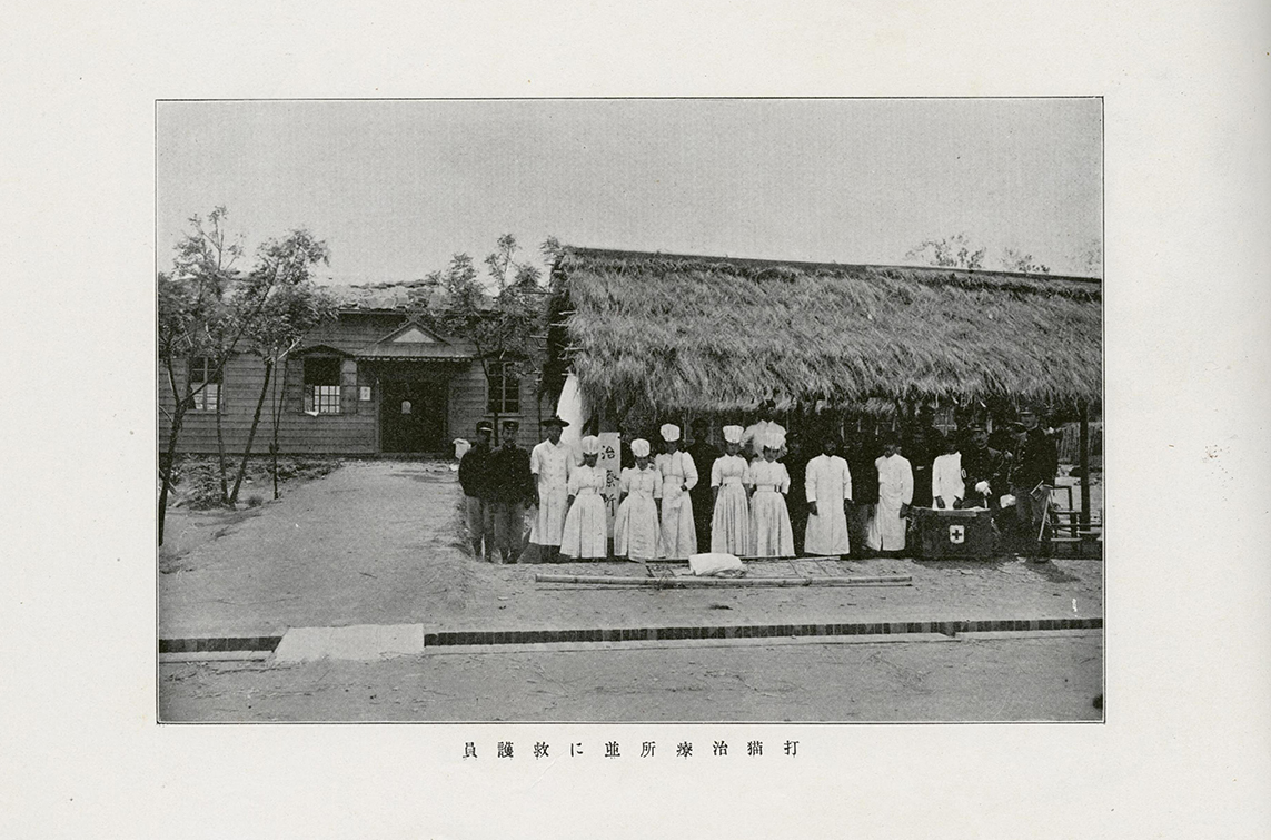
[fig 6] Unknown author, Sanitary Team working at the Damao Dispensary (Dabyo Shiryo Johei ni kyogoin/ 打猫治寮所並に救護員), 1906, source: Taiwan Nichi Nichi Shimbun, True Photographical Report on the Southern Taiwan Earthquake ( Nanbu Taiwan shinsai shashinjō 南部臺灣震災寫真帖), Taipei, Taiwan Nichi Nichi Shimbun, 1906, p. 83.
[26] Japanese Red Cross Society (Nihon Sekijujisha), Present Section Development History (Kyoku shibu hattatsu rekishi), inv. JRC1-058, 1911, Japanese Red Cross Society, pp. 635-646.
[27] Réginald Kann, « Formose, première colonie japonaise », in: Le Tour du monde : nouveau journal des voyages, Tome 13, Num. 51, pp. 12.1907, pp. 601-624.
[28] Gregory John DePies, Takashi Fujitani (exa.), Humanitarian Empire: The Red Cross in Japan, 1877-1945 (dissertation), University of California, San Diego, 2013, pp. 94-95.
[29] Anne Rasmussen , « L’hygiène en congrès (1852-1912) : circulation et configuration internationale », in: Patrice Bourdelais (dir.), Les hygiénistes : enjeux, modèles et pratiques, Paris, Belin, 2001.
[30] Hsieh Min-ro, “Taiwan’s Medical Education and Doctors’ Training during the Japanese Colonial Period”, in: Archives of Institute of Taiwan History, 23.07.2018, View source, consulted on 11.01.2026.
The management of the crisis on a sanitary level left little traces in the archives, notably from the Japanese Red-Cross, the main humanitarian organisation present in Taiwan during the colonization. The archives of the Japanese Red Cross Society or the Japanese Red Cross College of Nursing keep records of disaster relief interventions, but in the case of the Meishan Earthquake, we must turn our gaze to the JRCS archives, where yearly reports are kept, for example for Meiji era year 29[26]. However, other sources mention the relief and rescue efforts from an external point of view. Besides the report of the earthquake seen above, we can mention the report of French reporter Réginald Kann, “Rapport sur Formose”. Already acquainted with the Japanese in Manchuria, he was visiting the island when the earthquake occurred and decided to investigate the stricken areas in early 1906. The crossing of both sources allows one to understand the methodology of intervention in colonial context[27].
It is worthy to note here the nature of the relationship between the Japanese Red Cross Society and the authorities. Since the JRCS was established by a member of the kazoku and the member of the State apparatus, in addition to being sponsored by the Imperial House. The local Red Cross had been pretty much an exterior organization with international connections that had been co-opted by the Meiji government for a large part. By the outbreak of the Russo-Japanese War in 1904-5, the Red Cross was integrated in the Japanese military infrastructure. Moreover, the JRCS was the centerpiece of a larger soft power strategy to showcase Japanese moral and civilizational progress to Western Powers[28].
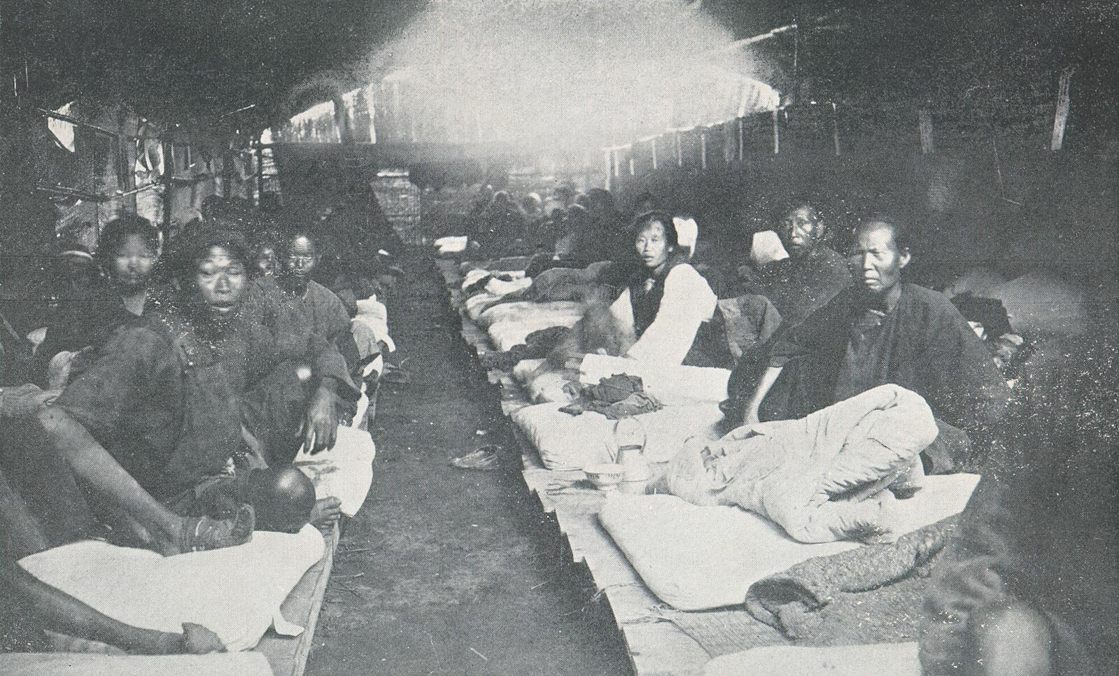
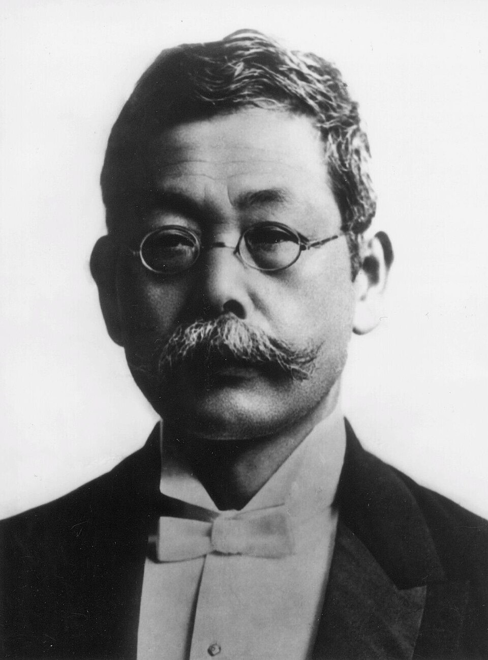
Since a majority of buildings have collapsed or been damaged, the relief and rescue efforts had to be conducted in temporary buildings. It mostly took the form of tents or thatched bamboo shacks where the injured people were taken care of. A particular attention is put on the aeration and the spacing between beds, to hinder the spread of any infections, corresponding to the hygienist theories popular at the dawn of the 20th century[29]. According to Kann, the medical personnel are composed of both Japanese and Han Taiwanese. Surgeons and doctors coming from all provinces of the island seemed to participate in the operations, Japanese surgeons as well as Han ones formed in the Taihoku Medical School (Taihoku Igaku gakkō), founded in 1902 by Takagi Tomoe[30].
It is worthy to note here the nature of the relationship between the Japanese Red Cross Society and the authorities. Since the JRCS was established by a member of the kazoku and the member of the State apparatus, in addition to being sponsored by the Imperial House. The local Red Cross had been pretty much an exterior organization with international connections that had been co-opted by the Meiji government for a large part. By the outbreak of the Russo-Japanese War in 1904-5, the Red Cross was integrated in the Japanese military infrastructure. Moreover, the JRCS was the centerpiece of a larger soft power strategy to showcase Japanese moral and civilizational progress to Western Powers[28].
Since a majority of buildings have collapsed or been damaged, the relief and rescue efforts had to be conducted in temporary buildings. It mostly took the form of tents or thatched bamboo shacks where the injured people were taken care of. A particular attention is put on the aeration and the spacing between beds, to hinder the spread of any infections, corresponding to the hygienist theories popular at the dawn of the 20th century[29]. According to Kann, the medical personnel are composed of both Japanese and Han Taiwanese. Surgeons and doctors coming from all provinces of the island seemed to participate in the operations, Japanese surgeons as well as Han ones formed in the Taihoku Medical School (Taihoku Igaku gakkō), founded in 1902 by Takagi Tomoe[30].
[fig. 7] Hashimoto Hakusui 橋本白水, Tomoe Takagi, Japanese Doctor and Educator in Taiwan, 1928, source: Sectors and Characters of Taiwan (Taiwan no Shigyokai to Jinbutsu/臺灣の事業界と人物), 1999, View source.

[31] Réginald Kann, op. cit., p. 605.
[32] Miao, Y.-W. (2013). From the “Natural Foot Society” to the “Unbinding Society”: The Politics of the Female Body in Early Japanese-Colonial Taiwan (1900–1915)/ 從「天然足會」到「解纏會」:日治初期台灣的女體政治 (1900-1915). 國立政治大學社會學系. National Chengchi University Institutional Repository, Article 140.119/62456.
[33] Taiwan Gouvernment General, Taiwan Gouvernment General Documents (Taiwan Sōtokufu Kōbun Ruisan), inv. T0797-05-029-0230, 30.03.1906, Institute of Taiwan History Archives, Taipei.
[34] William Favre, op. cit., chapter 3.2.2.
[35] Taiwan Government General, Ministry of Social Affairs, General Affairs Bureau (Taiwan Sōtokufu Minseibu Sōmukyoku), op. cit., 1907, pp. 315-329.
In total, the intervention team, whose core was made of 2 surgeons, 9 nurses (4 women and 5 men) and one secretary attended to 3’687 injured persons, among whom 1'583 came from Chiayi proper and 2’104 from the surroundings. The Japanese part of the city having sustained less destruction, most patients were Hans Taiwanese and mostly women, according to Kann[31]. The explanation is the practice of banded feet on women, preventing them from exiting a building in case of tremors. The extent to which this affirmation is true is up for debate, it seems indeed dubious that a majority of Han women at the time had banded feet, mostly because the majority of the population worked in agriculture, necessitating the workforce of women. The Institute of History of Taiwan states that 57% of women had binded feet in 1905. This fact would lead instead to a statistical bias with an overrepresentation of women with binded feet[32].
The material conditions of interventions seemed to be quite limited, which had been mentioned in the history of the Japanese Red Cross in Taiwan. The personnel seemed to have depended on different actors to sustain their relief efforts, among them the army and the local urbanites and rural inhabitants. A form of exchange was taking place between the humanitarian actors and the locals, receiving care or medicine in exchange of material resources.
How about the archives of the Sōtokufu? In the span of the three weeks following the original tremor, about 72 measures (teikyō) were taken, mostly by the Ministry of the Interior, to mitigate the crisis. The relief parties sent from Taipei and Taichung concentrated their efforts in the municipalities of Doliu, Chiayi and Yanshui. Beyond humanitarian forces, several members of the Government-General were engaged in the process as well, such as the Governor himself, Kodama Gentarō (1852-1906), who organized a part of the relationship between Taiwan and the home islands[33].
Imperial intervention explained partly that the communication between the two areas momentarily intensified. The Meiji Emperor played at multiple occasions an important symbolic role in the State response to natural disasters. By appearing personally in the stricken regions or by sending donations to those communities, the imperial institution cared for her subjects by benevolently aiding them by relief or donations. The occurrence of such an instance of public relation endeavor dated back to 1891, right after the Nōbi Earthquake, the first great catastrophe the Meiji Emperor had to cope with. Again during the 1896 Sanriku Tsunami, the Emperor personally visited the coastal villages of the eastern Tōhoku to fulfill his role of fatherly figure, based on Confucianist political principles[34].
In 1906, the Imperial House sent for example to the region of Daoliu the sum of 10 '000 yens in relief to the sub-prefecture. In the process of transfer, the Ministry of the Great Treasure (in charge of finances) played a critical role by transferring the sum to the receiving end. The total amount given by the Emperor is unknown, but seemed to have been spread over a span of two months from March to May 1906, most of the time, the destination of the donations in the reports are not specified[35].
In other words, the period that immediately followed the earthquake was marked by the rapid mobilization of the colonial government and the para-governemental organizations. Those rapid efforts were thought to bolster internally and externally the credibility of the Japanese colonial enterprise. The earthquake was the perfect opportunity to make the whole model-colony narrative more credible.
[fig. 8] Unknown author, Shelter for local people after the Great Kagi earthquake 1906 (Shoyosho Naibu (Honto Fushosha)/ 收容所內部(本島人負傷者)), 1906, source: Taiwan Nichi Nichi Shimbun, True Photographical Report on the Southern Taiwan Earthquake ( Nanbu Taiwan shinsai shashinjō 南部臺灣震災寫真帖), Taipei, Taiwan Nichi Nichi Shimbun, 1906, p. 45.
[36] William Camprich and Réginald Kann being the rare examples of that period.
[37] Nan-Wei Wu, ARCHITECTONICS OF SEISMICITY: Building and colonial culture in Japan and Taiwan from the Meiji Period to the Second World War (PhD dissertation), University of Edinburgh, Edinburgh, 2012, pp. 155-160.
[38] A good example of such problem is the reconstruction of Tokyo after the Great Kanto of 1923: Charles Schenking, The Great Kantō Earthquake and the Chimera of National Reconstruction in Japan, Columbia University Press, Columbia, 2013
[39] Paul D. Barclay, “Japanese Empire in Taiwan”, in: Oxford Research Encyclopedia, June 2020,
DOI: 10.1093/acrefore/9780190277727.013.376, pp. 18-26.
[40] Taiwan Government General, Ministry of Social Affairs, General Affairs Bureau (Taiwan Sōtokufu Minseibu Sōmukyoku), op. cit., 1907, pp. 383-390.
Part 2: Reconstruction Efforts
Reconstruction efforts properly began once the dust was settled and that restoration works had advanced enough to consider the city's future outlook of the city and the region. Chiayi had been, like we have seen, mostly destroyed by the earthquake. The lessons of 1906 led the authorities in Taipei to lay out a new plan for the city. Two factors were at play here: firstly, the central government of Tokyo didn’t intervene really much in the ways of the Government-General due to the distance with the capital and secondly, the fact that Taiwan was a Japanese colony and at the periphery of major international focus would attract less scrutiny from foreigners[36]. The result, according to Wu Nanwei, is that the Japanese architects and urban planners enjoyed more space away from judgement to experiment other forms of architecture or urbanism, impossible to consider in the mainland[37]. Taipei, in that respect, would become during the colonial period a laboratory for colonial modernity. So would it be for Chiayi, to a smaller extent.
Unlike the 1904 earthquake in the same region, when the Sōtokufu didn’t have enough means to intervene. The preparation level was higher compared to two years prior, with already a few suggestions made by Sano and Ōmori on the architectural changes to be implemented to strengthen the local buildings: the use of a wooden frame of the use of an iron-framing inside the brick-buildings to make the overall structure less susceptible to collapse.
After that came the much more technical step of the negotiations for the new urban plan of the Chiayo area, including the ruined city. This step is usually, in the aftermath of an earthquake, the most delicate due to its transition from the stage of a plan to its concrete occurrence in the landscapes. The introduction of a new spatial layout may often set the hopes of architects and planners pretty high. The main issue is that values and changes those same planners sought to implement tend to be sized down or to be abandoned altogether[38]. The reasons behind this lag between plans and reality can be put on a multiplicity of factors, a major one being the lack of financial means or human factors that could hinder the completion of the project. Pushbacks from the bottom up movements can modify the trajectory of such extensive and ambitious projects as well.
In the case of the Chiayi area, things were slightly different since the colonial status of Taiwan. Despite being the numerical majority, the Han people are in a political minority situation, leaving them very little space to express themselves politically. The state of archives of the colonial period, with a few traces of the possible Han pushbacks, do not allow us to really conclude in one direction or another. However, we may hypothesize the presence of local resistances, in one form or another, against the measure taken by the Japanese colonists, without the consent of subjects.
A good idea of the plans envisioned by the Japanese colonial urban planners can be seen in the History of the Chiayi region earthquake (1604-1906) (Kagi Chihō Shinsaishi). The extensive report, written a few months after the Chiayi/ Meishan Earthquake, gives us an important and official throwback of the events before and after the earthquake. To the historian, such a document reveals to be a treasure trove since it gives a very detailed narrative of the earthquake and its management by the different actors[39]. We must however keep in mind that these official recounts of the catastrophe always gave us the official standpoint of the events, putting the authorities in a favorable position. One must then try to find any other pieces of evidence able to offer a less partial point of view of the events.
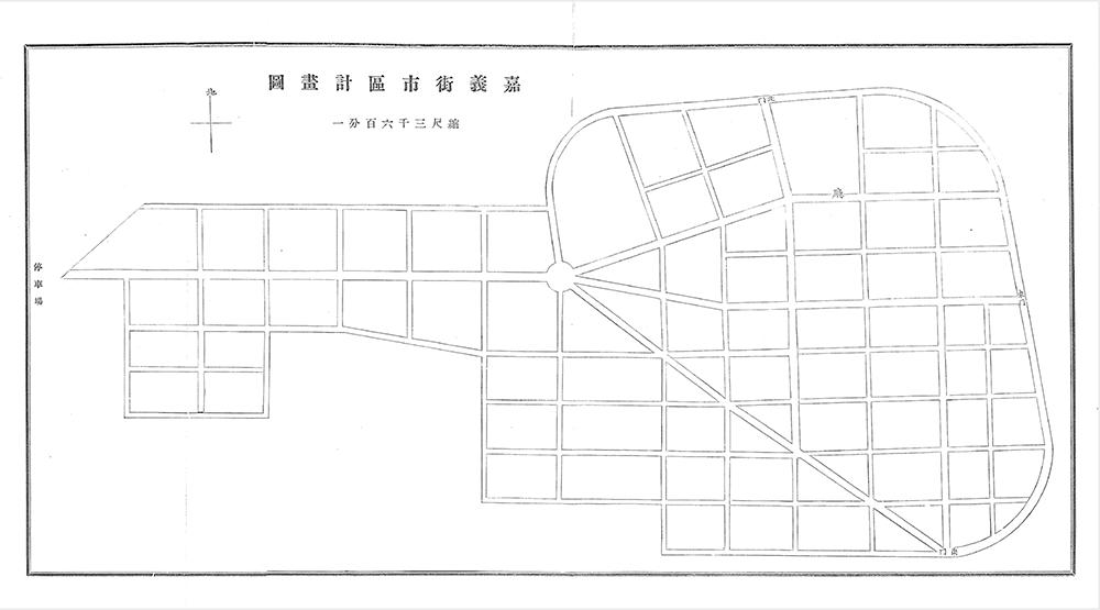
The plans devised by the Chiayi prefectural government were accepted on May 1st, less than two months after the initial disaster. Since a majority of the city was destroyed in the tremors and the damaged buildings destroyed, the plan advised to profoundly alter the layout of the city[40]. The outskirts of the former city were integrated into the urban core of the new Chiayi city, whose boundaries were defined by large peripheral avenues. The city blocks and the street arrangement were rearranged as well to fit a stricter quadrilinear layout. Inner boulevards transect the city to meet in a central place.
Unlike the 1904 earthquake in the same region, when the Sōtokufu didn’t have enough means to intervene. The preparation level was higher compared to two years prior, with already a few suggestions made by Sano and Ōmori on the architectural changes to be implemented to strengthen the local buildings: the use of a wooden frame of the use of an iron-framing inside the brick-buildings to make the overall structure less susceptible to collapse.
After that came the much more technical step of the negotiations for the new urban plan of the Chiayo area, including the ruined city. This step is usually, in the aftermath of an earthquake, the most delicate due to its transition from the stage of a plan to its concrete occurrence in the landscapes. The introduction of a new spatial layout may often set the hopes of architects and planners pretty high. The main issue is that values and changes those same planners sought to implement tend to be sized down or to be abandoned altogether[38]. The reasons behind this lag between plans and reality can be put on a multiplicity of factors, a major one being the lack of financial means or human factors that could hinder the completion of the project. Pushbacks from the bottom up movements can modify the trajectory of such extensive and ambitious projects as well.
In the case of the Chiayi area, things were slightly different since the colonial status of Taiwan. Despite being the numerical majority, the Han people are in a political minority situation, leaving them very little space to express themselves politically. The state of archives of the colonial period, with a few traces of the possible Han pushbacks, do not allow us to really conclude in one direction or another. However, we may hypothesize the presence of local resistances, in one form or another, against the measure taken by the Japanese colonists, without the consent of subjects.
A good idea of the plans envisioned by the Japanese colonial urban planners can be seen in the History of the Chiayi region earthquake (1604-1906) (Kagi Chihō Shinsaishi). The extensive report, written a few months after the Chiayi/ Meishan Earthquake, gives us an important and official throwback of the events before and after the earthquake. To the historian, such a document reveals to be a treasure trove since it gives a very detailed narrative of the earthquake and its management by the different actors[39]. We must however keep in mind that these official recounts of the catastrophe always gave us the official standpoint of the events, putting the authorities in a favorable position. One must then try to find any other pieces of evidence able to offer a less partial point of view of the events.
The plans devised by the Chiayi prefectural government were accepted on May 1st, less than two months after the initial disaster. Since a majority of the city was destroyed in the tremors and the damaged buildings destroyed, the plan advised to profoundly alter the layout of the city[40]. The outskirts of the former city were integrated into the urban core of the new Chiayi city, whose boundaries were defined by large peripheral avenues. The city blocks and the street arrangement were rearranged as well to fit a stricter quadrilinear layout. Inner boulevards transect the city to meet in a central place.
[fig. 9] Government-General of Taiwan, Proposition of Plan of Chiayi Layout (Kagi Shigai Kukei Shozu/嘉義市街区計書図), 1907, source: Government-General of Taiwan, History of the Chiayi Region earthquake (1604-1906) (Kagi Chihō Shinsaishi/嘉義地方震災誌), 1907, Taipei, p. 458.
[41] Samuel C. Chu, "Liu Ming-ch'uan and Modernization of Taiwan.", in: The Journal of Asian Studies. Vol. 23, No. 1 (Nov., 1963), pp. 37–53.
[42] Nashizawa Yasuhiko, “A Study of Japanese Colonial Architecture in East-Asia”, in: Kuroishi Izumi, Constructing the Colonized Land: Entwined Perspectives of East Asia around WWII, Ashgate Publishing, London, 2014, pp. 50-52.
[43] James W. Davidson, Formosa under Japanese rule, Japan Society, London, 1903, p. 43.
[44] André Sorensen, The Making of Urban Japan: Cities and Planning from Edo to the Twenty First Century, Routeledge, London, 2002, p. 50.
[45] Chu-Joe Hsia, “Theorizing colonial architecture and urbanism: building colonial modernity in Taiwan”, in: Inter-Asia Cultural Studies, Vol. 3, Num. 1, 2002, pp. 8-23, p. 10.
[46] Pratik Chakrabarti, Medicine and Empire: 1600-1960, Red Globe Press, Basingstoke, 2013, p. 12.
[47] Paul R. Katz, Germs of Disaster : the impact of Epidemics on Japanese mïlitary campaigns in Taïwan, 1874 and 1895, in: Annales de démographie historique, 1996. Morbidité, mortalité, santé. pp. 195-220, pp. 209-213.
From an urbanistic point of view, the reconstruction of Chiayi proposed an urbanistic programme similar to what could be found in Taipei (J.: Taihoku) during Japanese rule. Being the headquarters of the Japanese Government-General, Taipei concentrated the modifications done in the first years of the colonization in the urban planning of Taiwan. We must not forget however that Qing-period Taipei, right before the Japanese, saw the first elements of modernization to urban planning by governor Liu Mingchuan[41]. He tried to implement for example electrification and transportation means in the form of rickshaw. The Japanese pushed further those very changes by proposing a denser grid, with the adjunction of a transport system and leisure areas, plus the various administrative buildings. Like in other colonial capitals, the Japanese sought to materialize into urban spaces their vision of modernity and of colonial authority[42].
However, at the moment when the earthquake shook central Taiwan, the architectural program of modifying Taipei into what was considered fit has not yet been fully realized. In roughly ten years after the initial occupation of Taipei, the Japanese have succeeded to change the face of colonial Taipei, based on the testimonies of the period. With the architects of those urban changes being Kodama Gentarō, Gotō Shimpei and William K. Burton, a water transportation system as well as a railways system began to take shape, among others[43]. For their inspiration, the colonial administrators turned their gaze to Tōkyō, the imperial capital, itself undergoing important transformations based on different European cities like Paris[44].
In the case of Chiayi, the urban and architectural transformation was seen as an opportunity to incarnate the civilising mission of the Japanese in the region and to make Chiayi an example of colonial success. The cityscape embodied the new values of colonial modernity the Japanese sought to infuse to Chiayi. By colonial modernity, we must understand that the Japanese colonizers saw themselves as the promethean arbingers of modernity to a “backward” island at the fringe of the Qing Empire[45]. In terms of architecture and urbanism, the program of modernization was akin to a shift to the values deemed modern by the colonizers, inscribed in space: rationalism and spatial efficiency among others.
A supplementary value was represented by hygienism, being an important part of the Japanese colonial programme for Taiwan. Subtropical territories and tropical climates were deemed unsanitary by most colonizing powers, who considered the climate and diseases associated with these regions as reasons for their "underdevelopment"[46]. Modern medicine and hygienism were seen then as a means to improve the situation of the societies under colonial rule. Moreover, the fears of contamination of colonial powers could sometimes be legitimate, since tropical disease caused significant human casualties to colonial troops. During the conquest of Taiwan and the First Sino-Japanese War, most Japanese soldiers died of disease rather than warfare[47]. During the invasion of Taiwan, among the 37’000 troopers sent by Japan, 6900 soldiers died of tropical diseases. The aftermath of the earthquake allowed the urban planners to enlarge the streets, with the hope to ease the circulation of fresh air and the access of medical personnel to every part of the city. The ultimate goal was to make the city “safer” and “sanitary” for the settlers and for the local inhabitants in a secondary fashion, since its natural state was perceived as chaotic and therefore unhygienic.
[fig. 10] Government-General of Taiwan, Kagi Map in 1935 (Kagi Shigai Ryakuzu/嘉義市街略図), 1935, source: Government-General of Taiwan, Taiwan Rail Travel Guidebook (Taiwan Tetsudo Ryoko Annai/台湾鉄道旅行案内), Taipei, 1935.
[48] Gennifer S.Weisenfeld, Imaging Disaster : Tokyo and the Visual Culture of Japan’s Great Earthquake of 1923, University of California Press, Berkeley, 2012, pp. 253-295.
[49] The Bing Wu Earthquake Monument. Pbdragonwang, 嘉義明治丙午烈震賑災紀念碑, 2020, Wikimedia Commons, View source.
[50] Chen Kuan-fei, “Modernizing Chiayi: The Development of the Lumber Industry, 1914–1945”, in: Ruhr Universität Bochum (Taiwan als Pionier), 2022, View source.
[51] Chinese Geological Bureau, 日據時期嘉南地區歷史地震資料之重新整理與分析 台灣地區十大災害地震圖集, Central Weather Bureau, 2011, p. 207.
In the architectural and urbanistic array deployed by the Japanese actors for reconstruction, one may include a memorial side too. In Japan, seismicity constituted an important factor in local cultures of the archipelago, whose traces of past catastrophes were etched in space by the use of markers of many kinds. These markers could take the form of stellas, temples or even mausoleums or museums[48]. The Sanriku coast saw a flurry of Tsunami stones dotting the landscapes after the devastating disaster of 1896, killing close to 20’000 people. In the case of Chiayi, the most important piece of memorialization was to establish the Kagi Park, nowadays known as the Memorial Park, which contains a stone monument in memory of the deceased citizens[49]. The memorial impact of this earthquake seems inversely proportional to its gravity, whose reasons remain to be explained.
Overall, the architectural success of the rebuilding of Chiayi must not overshadow certain parts of the plan being less well executed. The main issue of the reconstruction following 1906 is related to the root of its economic success. By focusing and relying on the industrial sector, whose train line and its sawmill led to. But the Taichung 1935 earthquake destroyed again those very strategic infrastructures, crippling the local timber industry, until its definitive downfall during the economic hardships due to repercussions of the Pacific War[50].
Another issue was the superficiality of the reconstruction works, where the plans aimed especially towards the demonstration of the quality of the Japanese colonial management. It led subsequently to the reconstruction works to be rushed and maybe actually not thought out thoroughly. It rejoins as well the narratives of the Japanese colonists focusing on the functional reconstruction of the city compared to the overall social aspects, funneling the reconstruction funds into the industrialization of the city instead of diversifying to other key sectors, mostly the conception of spaces accessible to the public.
The test of 1941, with the Changpu earthquake can evaluate the success or not on the long term of the modifications brought by the Japanese during the aftermath. Significantly less people perished during the earthquake. On the material side of things, however, the city of Chiayi and the township of Meishan, right besides Chiayi, were heavily hit[51]. Some 4 '520 dwellings were destroyed for example, alongside ruptures in gas, water and electricity infrastructures. The extent to which the choices of 1906 are to blame may be difficult yet paradoxical. Despite the diminution of the number of victims, the changes in policy to mitigate the earthquake did not bring significant changes to the real potential of mitigation of those measures, at least from a statistical point of view.
But why ? The reason for such a discrepancy is perhaps a lack of the measures taken, not going far enough. Despite widening the streets or the creation of green spaces, the reglementation in construction requirements seemingly hadn’t been followed or applied strictly, leading to structural fragilities. The reasons for the continuation of collapse-prone buildings could be numerous, but cost effectiveness and availability are amongst the main reasons, seemingly.
Thus, despite the apparent modernization of Chiayi’s urban landscape, the deeper structural issues remained unresolved. Financial limitations, uneven enforcement of building codes, and the prioritization of industrial growth over comprehensive urban safety all contributed to a reconstruction that looked modern but, in many ways, remained precarious.
[fig. 11] Unknown author, Ruins of a gate of Chiayi city (Chiayi Xuan Cheng Yiji/ 嘉義縣城遺跡), 1910, source: Wikimedia/ Barbara Hsu, View source.
[52] Gregory K. Clancey, Earthquake Nation. The Cultural Politics of Japanese Seismicity, 1868-1930, University of California Press, Berkeley, 2006, pp. 175-177.
[53] Kim Boumsong, “Seismicity Within and Beyond the Empire: Japanese Seismological Investigation in Taiwan and its Global Deployment, 1895–1909”, in:East Asian Science, Vol. 1, 2007, pp. 153–165. https://doi.org/10.1007/s12280-007-9018-1
[54] Richard H. Grove, Green Imperialism. Colonial Expansion, Tropical Island Edens and the Origins of Environmentalism, 1600–1860, Cambridge University Press, Cambridge, 1996, p. 12.
[55] Name given in japanese to the sun-dried bricks.
[56] Ōmori Fusakichi, “Preliminary Note on the Formosa Earthquake of March 17, 1906”, in: Bulletin of the Imperial Earthquake Investigation Committee, Vol. 1, Num. 2, pp. 53-69, p. 55.
[57] idem, PL. XXI., Fig. 9.
[58] T. A. Roy, “War in the camphor zone: Indigenous resistance to colonial capitalism in upland Taiwan, 1895–1915”, in: Japan Forum, Vol. 34(3), 2022, pp. 333–354, pp. 9-19.
Part 3: Seismic Coloniality ?
Once we saw the reconstruction efforts and their consequences on the region of Chiayi. Let’s now turn our scrutiny to the relationship to coloniality and seismicity. The Meishan earthquake not only exposed the material vulnerabilities of Taiwanese society but also became a tool through which the Japanese colonial state consolidated authority, justified infrastructural expansion, and accelerated territorial and social reorganization. Kim Boumsong and Gregory Clancey have already covered in their respective works some aspects of that relationship in the Taiwanese context[52]. By seismic coloniality, we tentatively describe here the way that the Japanese empire and its agents use earthquakes to justify colonization of the Taiwanese population, but also using the crisis ushered by the tremor to use it as an opportunity to restructure the colonial society of Chiayi[53]. We may even say that the seismic event and its management by colonial authorities were used to tighten the grip of Japan on the Chiayi region.
The concept of seismic coloniality seeks to build upon the basis laid by the works of Kim and Clancey, putting a name on the intersection of coloniality, science and the environment. One may argue rightfully that the concept is a subset of green imperialism[54]. The nuance we ought to bring is the element of disaster developed by seismic coloniality. The difference brought by earthquakes is the unpredictability of the tremors and the tremendous human and material cost, leading the colonial administration and agents to find a way to mitigate the risk and their control on the colonial societies by this lever.
However, both historians had mainly focused their analysis on the scientific aspect of the Meishan-Chiayi disaster. Indeed, seismology served as a tool to undermine the legitimacy of the local vernacular architecture compared to modern Japanese architecture. Ōmori Fusakichi, in his article on the earthquake, accused the mudbrick frame and the light use of cement to lead to the high number of casualties. The article states: “The consequence of such a bad method of construction, joined to the heaviness of the roof, is that the native houses are, at the occurrence of a violent shock, at once shattered to pieces, leaving little time for the people to escape. The easiness with which the dokaku[55] houses are overthrown may be seen from the fact that the town of Dabyo was almost entirely levelled to the ground with the exception of the Sub-Prefectural Office, a brick one-story building with a two-story tower, which suffered no severe damage except some cracks in walls and the falling down of part of the roof tiles”[56].
Ōmori notes that the wooden framed houses withstood better the shock of the earthquake. Beyond the simple legitimate observation that the structure of wood allowed a better mechanical resistance to tremors, the seismologist established a link between this type of Taiwanese architecture and traditional Japanese wooden architecture. The established parallel is instrumentalized to implicitly prove that Japanese carpentry and engineering is superior to the local style. The contrast is even shown in image: whereas the new Japanese-style sub-prefectural building stayed stable overall, the local Maso temple just crumbled to the ground[57]. Such a narrative is part of a larger argument justified in the eyes of Ōmori, the Japanese presence in Taiwan. Despite tremors and the presence of white ants, in other words a hostile environment, the Japanese architecture seemed to hold somehow in place.
The argument of Ōmori overlooked however different factors that could invalidate his narrative. The first point is the management of resources or convenience, where timber could be a precious resource, situated mostly in the neighboring mountains, in aboriginal territory[58]. The second is practical and linked to the properties of earth as a construction material. Earth or adobe is commonly used in tropical climates in vernacular architecture for its thermic isolation properties. In the humid tropical climate of central Taiwan, the use of mud brick represented a wise choice given its abundance and isolating properties. The third argument is the simple fact that official buildings, representing colonial power and modernity, were thoroughly destroyed by the disaster, discrediting directly the presumed superiority of Japanese architecture, built in bricks too.
[59] William Favre, “Shibusawa Motoji and the Great Kantō Earthquake of 1923”, in: Tokinomichi, 10.02.2025, View source.
[60] Jun Uchida, Brokers of Empire. Japanese Settler Colonialism in Korea, 1876-1945, Harvard University Asia Center, Harvard, 2005, p. 125.
[61] Ramon H. Myers; Mark Peattie (eds.), The Japanese Colonial Empire, 1895-1945, Princeton University Press, Princeton, 1985, pp. 49-50.
Both Clancey and Kim demonstrated the intimate link between science and coloniality in the Japanese context. However, both historians didn’t consider the relationship between seismicity and coloniality itself. In fact, seismicity can be considered a supplementary criteria in the colonial history of Taiwan. We may assume firstly that Taiwanese seismicity is predominantly a hindering factor. However, seismicity has an agency of its own given the context it manifests. Some factors could be manifestly considered less profitable for the Japanese colonizers, based on their impact upon the analyzed actors. Tropical diseases, for example malaria and yellow fever played a major role in slowing the Japanese occupation of the island due to the ravages it has done on the troops. For the Republic of Taiwan, this factor was in fact a welcome news, undermining temporarily the attack of the Japanese forces. Thus, all environmental factors are contingent to their context and are intimately linked to their anthropo-social dimension.
The specific role of seismicity in the complex social panorama of the colonial Taiwanese society under Japanese administration was one of punctual perturbations that were able to shift the lines of the socio-political configuration of the stricken areas. In fact, this shift provoked by a seismic disaster rarely shifts those lines beyond the regional scale. On the rare occasions of the contrary, repercussions may become national even global if the earthquake occurs at a strategic placement, or political hub, for example Tokyo in 1923 being the perfect example[59].
In the case of the region of Chiayi (Kagi-chō), the local society was built in a pyramidal structure with three major groups: the Japanese colonizers, the Han Chinese and the Taiwanese aboriginals, mainly the Tsou and the Hoanya people. The two first groups concentrated themselves in the plains and the aboriginals in the mountainous hinterland. The aboriginals played a later role due to the location of the bulk of the damages in the plains. These pyramidal structures in the social ladder could be seen as well in the urban outlook of Chiayi, where the Japanese separated themselves spatially from the Han majority by constructing and living in their own quarters[60]. It reflected the political order of the Japanese colonial period too, where the political and economical power was mainly detained by the Japanese, in the administration and in the key posts in the economy or land property.
The main difference of the Japanese colonial period, contrary to the Qing administration, was the intention of the Japanese to make a model and a modern colony out of Taiwan. How so ? By applying among other proceedings the application of “scientific colonialism” inspired by the German style of colonialism, whose management style had very strong technocratic tonalities[61]. Yet again, we could see in Taiwan an interpenetration of science with coloniality, with very early on important operations of civil engineering to support infrastructures needed for the Japanese colonizers. Here is a leitmotif that will be found throughout the whole Japanese empire. The objective was to emulate the industrialization of the Japanese home islands, whose industrial revolution leaned on the creation of a railway network and the deployment of communications.
[fig. 13] Torii Ryūzō, The Tsou hunters ( Torii Ryūzō Sessū zoku Ryonin/鳥居龍藏所攝鄒族獵人), 1900, source: Wikimedia, View source.
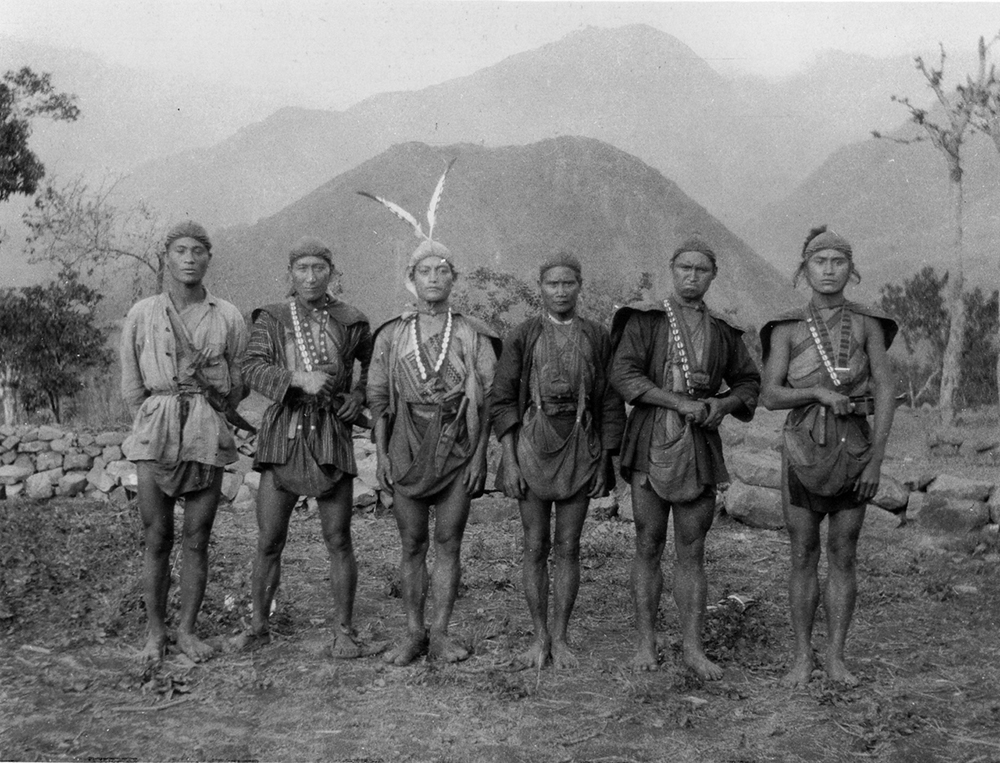
[62] Catherine Hsieh, "The historical impact of earthquake damage on Taiwan society and culture", in: Taiwan Journal, 26 Oct 2001, p. 17.
[63] Here’s an example of resilience study: David Mendonça, Inês Amorim, Maíra Kagohara, “An historical perspective on community resilience: The case of the 1755 Lisbon Earthquake”, in: International Journal of Disaster Risk Reduction, Vol. 34, 2019, pp. 363-374.
[64] Ramon H. Myers; Mark Peattie (eds.), op. cit., p. 14.
[65] Takahashi Yasutaka, Nihon shokuminchi tetsudō shiron, Nihon Keizai Hyōronsha, Tokyo, 1995.
[66] Alexandra Mustatea, “On the Convolutions of Modernity and Confucianism in Japan Loyalty from Yamaga Sokō’s Shidō to Prewar Kokutai Ideology”, in: European Journal of Japanese Philosophy, Vol. 4, 2019, pp. 131–155, pp. 134-136.
[67] Pierre-François Souyri, Moderne sans être occidental - Aux origines du Japon d’aujourd’hui, Gallimard, Paris, 2016, chapter 6.
[68] Kang-Chi Hung, “When the green archipelago encountered formosa the making of modern forestry in Taiwan under Japan’s colonial rule (1895-1945)”, in: Batten, Bruce Loyd, and Philip C. Brown, eds. Environment and Society in the Japanese Islands : From Prehistory to the Present. Corvallis: Oregon State University Press, 2015, pp. 173-194.
[69] Komeie Taisaku, “Japanese Colonial Forestry and Treeless Islands of Penghu: Afforestation Project and Controversy over Environmental History», in: Geographical Review of Japan, Series B, Vol. 93( 2), 2020, pp. 50–65, pp. 60-62.
Thus seismicity as a disrupting element affected for one part the infrastructures or lifelines on which the Japanese to maintain and to make the colony function but also contained an immaterial dimension. By immaterial, we mean here that the impact of seismicity extended to the social realm too. The tremors put under pressure the social order existing in the region by the sheer crisis represented by the destruction of one part of the city and the loss of many human lives[62]. We may assume the emotional and psychological impact of such a sudden alteration of one’s daily life and the shattering of their reference points. The resilience, or the capacity of those stricken communities to rebound, can then only be analyzed properly in retrospect, after enough time has passed to assess the actual rebound or its absence[63].
In this case of Chiayi and its surrounding region, and as we have seen above, the Government-General in Taipei reacted quite quickly by a sizable relief and aid force from the colonial capital. The city being destroyed in a consequent portion and the taking in charge of the injured persons or to dispose of the deceased seemed to have demanded more manpower and energy that the already vulnerable local population could furnish. From that point of view, the Government-General’s decision was welcomed by the population, who had to shelter in makeshift homes and tents for the following weeks.
The Japanese intervention had a positive effect on the population of Chiayi region by restoring a part of its previous autonomy and functionality to the population. We must not forget however that the act wasn’t fully benevolent and aimed for political practical reasons. By restoring and rebuilding the region, the Government-General could reconstitute the productive capacity of the area, notably in its key-resources: timber and sugar, mainly. The whole colony had been administered by taking inspiration from other European colonies situated in the region, for example in the Dutch East Indies[64]. Beside the German inspiration we cited before, we can cite the British example, with the role played by certain technologies in the colonial administration, notably the railways. Railways were essentially used by the colonizers to move goods around, mostly to the open ports of Taiwan to be shipped to the home islands, or to foreign markets[65].
The sending of forces could be seen as a measure from the colonial state to restore the local social order strongly shaken by the earthquake. Particularly in the East Asian political imaginary infused by confucianist philosophical elements, the occurrence of a disaster can be interpreted as a sign of misgovernment by the sovereigns. In this case, in order to prevent his government from further degrading omens, the sovereign has to shift its policy towards an objective in tune with the social ideals of a caring sovereign[66]. In the case of an earthquake, the most logical measure to take would be to send a rescue party to relieve the stricken area. The underlying element at play is that the pragmatic exchange between the governor and governed forms the base of a Rousseauian “social contract”. In exchange for the obedience of their population, the sovereign must sustain, feed and protect them. In a way, this is what the philosopher and theorist Mengzi called the “mandate of heaven” in his writings.
The Meiji political ideology and imagination was a pragmatic mix of native, Chinese and Western elements, notably social darwinism and neo-confucianism dating back to the Edo period. Being the guarantor of the harmony and the unity of the Japanese society, the Emperor and the Meiji Oligarchy sought to contain any events or movements that hinder the political harmony or the current state of affairs[67]. By dispatching troops or officials represented as more of a political gesture than a symbolic one, meaning by that a restoration of the civil order.
Moreover and in the longer run, the investment of the Government-General has to be considered as an economic gambit put on the region, since the Government-General and the prefectural government sought to gain back a portion of the funds invested in the restoration and reconstruction process. In the case of Chiayi, a further step was achieved by the boom in extractive industries of the region: namely sugar, wood and tropical fruits. Even before the earthquake, the lush forests of the mountainous heartland raised the interest of the Japanese colonizers[68]. The earthquake worked as a pivotal moment because it gave the colonial actors of the city the push to respond the needs of the lumber industry. Among the valued lumbers, we could find pine trees and camphor trees, mainly used for photography upon which the colonial state had almost a monopoly. As we have seen, the Alishan Forest Railway played a crucial role by the spine being the extraction site and its processing center into the plain. However, the entirety of the lumber operations could not have been possible without violence against the aborigines, in particular the Tsou people. The intensive exploitation of forest resources was implemented by expropriation of the Tsou from their ancestral lands but also by what could be considered a war of pacification onto these same populations[69]. As pointed out by Paul Barclay, the 1900-1910’s saw the spike of intra-colonial military operations against the aboriginal territories. They aimed for two problems from the Japanese standpoint: suppressing the last pockets of aboriginal resistance and to secure parcels of forest where the precious camphor trees grew.
[fig. 14] Unknown author, Collecting timbers in Arisan (Arisan Shusai Kikai no Shusai Sakugyo 阿里山集材機械の集材作業), 1914, source: Government-General of Taiwan, Perspective on Statistics of Taiwan (Taiwan Tokei Yoran/ 臺灣統計要覽), Government-General of Taiwan, Taipei, 1914.
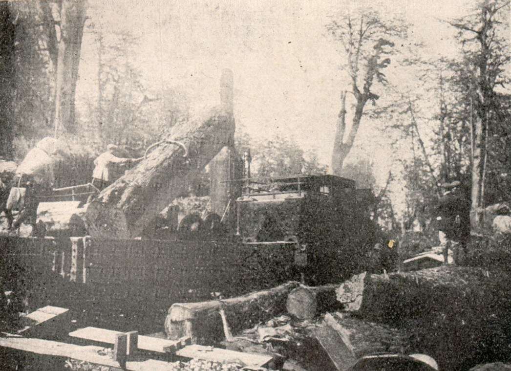
[70] Paul D. Barclay, Outcasts of Empire. Japan’s Rule on Taiwan’s “Savage Border,” 1874–1945, University of California Press, Oakland, 2018, p. 100; p. 106.
[71] Taiwan Government General, Ministry of Social Affairs, General Affairs Bureau (Taiwan Sōtokufu Minseibu Sōmukyoku), op. cit., 1907, pp. 393-395.
[72] Council of Indigenous People, “Cou”, in: Council of Indigenous People, 2020, View source.
[73] Kim Boumsoung, op. cit., p. 162.
[74] For more details, the work of Arakawa Shōji’s project research covers that very point: Imperial Japan and Colonial Disasters- Focusing on the Taiwan Earthquake History during the Japanese Colonial Period.
[75] Jenny Lin, “Sugar, Taiwan, and Japan. Sugar Industry in the Years From 1895 to 1945 When Taiwan Was Under Japanese Rule”, in: ArcGIS StoryMaps, 18.12.2022, View source, accessed 01.02.2026.
While the plains of Chiayi suffered the most direct physical impact of the 1906 Meishan earthquake, the indigenous populations of the surrounding highlands—particularly the Tsou and, to a lesser extent, the Hoanya—experienced the disaster through a distinct yet equally significant set of transformations. Their relationship to seismicity was shaped not only by geographic distance but also by the colonial strategies that governed their lands, mobility, and livelihoods. For the Tsou communities inhabiting the Alishan region, the earthquake’s indirect consequences were ultimately more disruptive than its immediate physical effects. Reconstruction in the lowlands intensified the Japanese quest for timber resources in the uplands, accelerating processes of expropriation, surveillance, and coercive incorporation into the colonial economy[70].
From an indigenous standpoint, seismicity did not operate as an isolated event but as part of an expanding series of colonial intrusions into ancestral territory. Japanese officials interpreted the destruction of lowland infrastructure as a justification to further secure forested mountains, to guarantee a stable timber supply for reconstruction[71]. In practice, this meant heightened military presence, more aggressive pacification campaigns, and the redrawing of territorial boundaries that restricted indigenous autonomy. The Tsou, whose socio-political organization was closely tied to their mountains, saw their traditional forest disturbed by the Japanese presence. However, one part of the Tsou people kept good diplomatic terms with the occupiers, believing that they were their long-lost cousins the Mayas. In asymmetrical exchange for the timber and camphor, the Tsou highlanders “accessed” Japanese technology and medicine[72]. The “recovery” of Chiayi thus came at the price of deepening dispossession in the uplands.
Moreover, the colonial narrative of architectural inferiority extended, implicitly, to indigenous building traditions. While Japanese engineers praised the supposed resilience of their wooden structures, they dismissed vernacular forms—whether Han mud-bricks or Tsou timber and bamboo construction—as outdated and unsuitable for a modern, earthquake-prone colony. These judgments, grounded in selective and often ideological interpretations of seismic performance, fed into policies that marginalized indigenous knowledge, despite its long-term adaptation to mountainous seismic and climatic conditions[73]. In this sense, seismicity became a rhetorical weapon used to undermine indigenous environmental practices and justify further intervention in their territories.
By integrating the indigenous perspective, the picture of seismic coloniality becomes more complete. The earthquake did not simply affect a Japanese–Han urban setting; it reverberated through a multiethnic frontier where vulnerability, reconstruction, and resource extraction intersected[74]. For the Tsou and Hoanya, the 1906 disaster marked not only a moment of distant tremors but a turning point that deepened the reach of the colonial state into their lands and lives. Their experience underscores that the consequences of seismicity in colonial Taiwan were not uniform but were filtered through existing hierarchies of ethnicity, geography, and political power.
The Meishan earthquake, in the longer-term aftermath, allowed a real economic rise of the Chiayi area by a better connection to the region on one hand, but on the other hand bolstered other economies that depended on a reliable railway connection. Two of the most notable examples for the Chiayi area were its sugarcane and logging industries.
The sugarcane industry was well known in Colonial Taiwan and was particularly for the plain regions of the island’s Eastern coast. Processed in refineries scattered across the island, the bulk of the final sugar was imported to the home islands. As the Japanese society industrialized and adopted more Western habits, so did its culinary culture. In general, the Japanese ate more sugar and diversified diets, with a relative decline of rice as the staple food. The rise of a sweet and bakery industry explained partially the growing production of Taiwanese sugar and the majority of the production going to Japan. The portion of the Taiwanese production exported to Japan could go as high as 70%, another 20% exported to other destinations and the remainder was locally consumed[75]. 1908 marked a peak in the opening of new sugar processing factories, competing out the native factories. We can argue here that the case of Chiayi enjoyed the consequences of a larger agro-industrial development plan by the Japanese Government-General. However, the local sugar industry seemed a secondary industry that contributed less to its communications and less to its economy.
[fig. 15] Unknown author, Japanese Period Annei Sugar Factory (Rìzhì shíqí de Ànnèi Tángchǎng/ 日治時期的岸內糖廠), circa 1908, source: A Hundred Years of Taiwanese Photography (Yībǎi nián qián de Táiwān Xiězhēn/一百年前的台灣寫真), 1995, Taipei, p. 131.
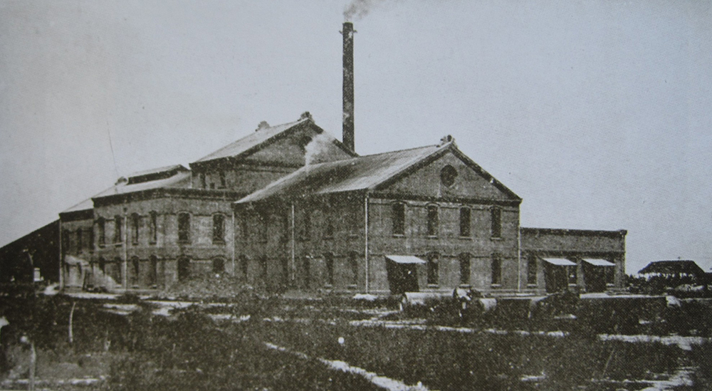
[76] Chao-Ching Fu, "Enlightening the Spirit of Industrial Heritage in Taiwan”, in: TICCIH Congress 2012 in Taiwan Proceedings, 2012, TICCIH, Taipei, pp. 22-35, p. 27-28.
[77] Alishan Forest Railway and Cultural Heritage Office, “Chiayi Sawmill”, in: Alishan Forest Railway and Cultural Heritage Office, 2019, View source, accessed 01.02.2026.
[78] Chen Kuan-fei, “Modernizing Chiayi: The Development of the Lumber Industry, 1914–1945”, in: Ruhr Universität Bochum (Taiwan als Pionier), 2022, View source.
The logging of the hinoki (cypress tree) can be considered as the main factor of economic growth in Chiayi after 1906, to the point of becoming the fourth city of Taiwan. The opening of the Alishan railways created a labor vacuum to be filled by workers coming from the rest of the island and by the adjacent services to the workers of the logging industry at opening of the railway in 1914[76]. The harvest was transported via train to the plains before being processed there or shipped elsewhere to the rest of the empire and stored in ponds in river tributaries. The colonial administrators from the forestry department sought to modernize the production by importing state of the art machinery for logging. Soon Chiayi would be known as the logging capital of the island[77]. Beyond the economy, the logging industry reshaped the social fabric of the city by employing at different positions Japanese, Chinese and Tsou people searching for employment in the lowlands. At Hokumon Station, the Forestry Bureau was based in the worker village built by the line operator, the Government General. Indeed, the mill was considered the biggest in Asia and the largest government-run venture during the Japanese colonial period[78].
[fig. 16] Taiwan Nichi Nichi Shashin Gahosha, Chiayi Timber Factory (Kagi Seisai Jo/嘉義製材所), September 1917, source: Daily Taiwan Illustrated Review (Taiwan Nichi Nichi Shashin Gaho/臺湾日日寫真画報), 1917.
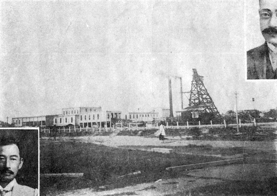
[79] Fu-Chen Lo, “FROM TAIWAN TO THE WORLD AND BACK: A MEMOIR BY LO FU-CHEN 榮町少年走天下”, in: Books from Taiwan, 2013, p. 8.
The rapid rebirth and even blossoming of the city, being the fourth most populated of Taiwan, gave Chiayi a reputation as an easy-living city. It attracted both Chinese and Japanese inhabitants, who were initially wary of leaving Japan due to the climatic and cultural distance of the town. In hindsight, the period of recovery and flourishing proved successful for the Japanese occupiers but for Taiwanese locals as well, since the reconstruction efforts indirectly increased their global quality of life. To the point where it overshadowed partly the violent first decade of the colonisation. This case of recovery shows the whole ambivalent spectrum of the colonialist relationship between Japan and Taiwan.
Chiayi became hence, socially and economically speaking, a regional hub of attractivity where the main population groups of Taiwan mingled, and accelerated the circulation of people and ideas on a local level in contrast to a more clustered situation in the past[79].
As said for the 1941 Changpu earthquake, the prosperity of the city was halted by destroying the industrial infrastructures of Alishan. The Pacific War effort worsened the situation until the Japanese surrender and the retrocession of Taiwan to the Republic of China in 1949. In the end, the case of Chiayi reveals how seismicity did not simply interrupt the colonial order but actively participated in reshaping it. The 1906 Meishan earthquake created a moment of political and material disruption that the Japanese colonial state rapidly transformed into an opportunity for consolidation. Relief efforts reinforced the legitimacy of the colonial administration, the discourse of scientific modernity justified deeper cultural and architectural intervention, and reconstruction projects facilitated the expansion of extractive infrastructures that tied Chiayi more tightly into the imperial economy. At the same time, the earthquake intensified social hierarchies by exposing differential vulnerabilities across ethnic, economic, and administrative lines. Far from being a neutral natural event, the Meishan disaster operated as a catalyst revealing—and amplifying—the structural asymmetries of colonial rule.
[fig. 17] Tan Teng-pho, Street of Chiayi, Chen Cheng-po, 1926, Canvas/ Oil painting, 64×53cm, Selection of Seventh "Empire Exhibition" of Japan.
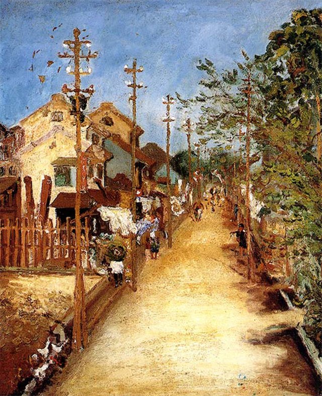
[80] The report created by the Government-General in 1907 is already a good example, further represented by the 1935 earthquake: N.J.P Alsford, ”The 1935 Hsinchu-Taichung Earthquake: Natural Disasters as Public History”, in: Public History Review, Vol. 27, 2020, pp. 1-16.
[81] N.J.P Alsford, ibid., pp. 4-7.
This dynamic captures what may be called seismic coloniality: the process by which geological disturbances interact with power relations and are mobilized, strategically or indirectly, to reinforce a colonial order. In Chiayi, seismicity generated both material destruction and political openings—openings that the Government-General of Taiwan converted into tools of governance, territorial control, and economic extraction[80]. The earthquake did not fundamentally overturn the colonial hierarchy, nor did it emancipate the populations who suffered its consequences. Instead, it reconfigured the colonial landscape by allowing the administration to legitimate its presence, intensify infrastructural penetration, and accelerate long-term plans of modernization rooted in unequal benefits across the social pyramid[81]. The ambivalent trajectory of Chiayi—from devastation to economic flourishing and, eventually, to renewed vulnerability by the 1941 Changpu quake—illustrates how seismicity became embedded in the very mechanics of colonial governance.
[82] Mike Davis, Late Victorian Holocausts El Niño Famines and the Making of the Third World, Verso, London; New York, 2001, part IV.
[83] Guillaume Blanc, op. cit, pp. 16-17
[84] Hill, Pamela, Environmental Justice: A Very Short Introduction, Very Short Introductions (New York, NY, 2025; online edn, Oxford Academic, 12 Aug. 2025), View source, accessed 01.02.2026.
Part 4: Colonial and Environmental/Climate Injustice
After analyzing the link between colonialism and seismicity in colonial Taiwan, let us turn our gaze to those same links binding disasters and colonialism in the rest of the Japanese Empire and in other colonial empires. As observed by Mike Davis in his research, imperialism and colonialism in the end of the 19th were direct aggravating factors in times of crisis and disaster for vulnerable populations[82]. Guillaume Blanc, on the other hand, made explicit the link between the colonial destruction of environments and conservationist movements, coming sometimes from the same social circles. Furthermore, he defines racism, a key-element to colonialism, as the naturalization of a social balance of power[83].
In fact, colonialism and imperialism were not only aggravating factors but also in certain contexts a cause to those same disasters. A perfect example is Global Warming and the larger phenomenon labeled as the Anthropocene. The minority of the planet’s population produce the most of the carbon dioxide and retain most of the global wealth whereas the majority must cope with the brunt of the negative externalities provoked by climate change with the rest of that global wealth[84].
In fact, colonialism and imperialism were not only aggravating factors but also in certain contexts a cause to those same disasters. A perfect example is Global Warming and the larger phenomenon labeled as the Anthropocene. The minority of the planet’s population produce the most of the carbon dioxide and retain most of the global wealth whereas the majority must cope with the brunt of the negative externalities provoked by climate change with the rest of that global wealth[84].
[fig. 18] Unknown author, Relief work during the great famine in South India, 1876-1878, View source.
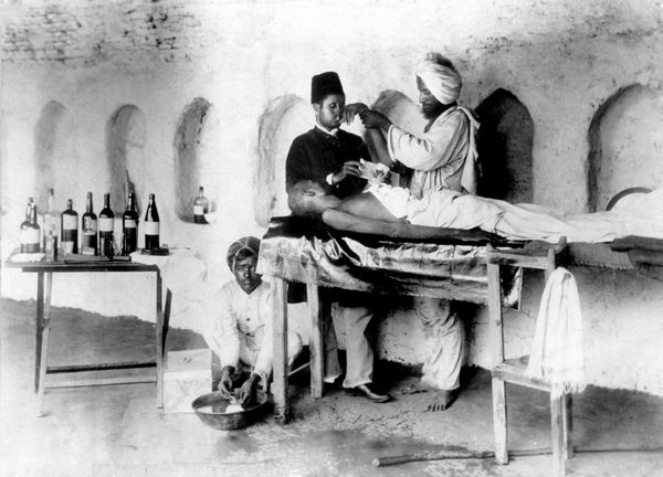
[85] Collective, “Anthropocene Detonators”, in: Feral Atlas, Stanford University Press, Stanford, 2021; Kent G. Lightfoot, Lee M. Panich, Tsim D. Schneider, Sara L. Gonzalez, “European colonialism and the Anthropocene: A view from the Pacific Coast of North America”, in: Anthropocene, Vol. 4, 2013, pp. 101-115.
[86] Victor Seow, Carbon Technocracy : Energy Regimes in Modern East Asia, University of Chicago Press, Chicago, 2021, Chapter 4.
[87] Cyrian Pitteloud, “La Commission d’Enquête sur la pollution minière d’Ashio de 1897 et ses enjeux : du laissez-faire à la prise en main étatique d’une crise environnementale.”, in: Cipango, Vol. 23, 2020, View source.
The notion of environmental justice is meant here as the necessity of fairness that must be addressed from the environmental and social point of view to populations or communities throughout history, whose livelihood and social fabrics have been deteriorated or perturbed by inequity in power or economical might among other factors. The structures concerned by this concept are the ones that allow such inequalities to persist and that are maintaining a situation of domination between multiple social groups or actors. In the context of colonialism, environmental (in)justice will apply to any social or political structures that allow the domination of one population on another, with the effect of losing at varying degrees their autonomy. The consequences of such a situation of a colonial relationship may vary, from the advent of alien species to the exploitation of the colonized realm, and the creation or aggravation of disasters (either natural or man-made)[85].
The same conclusion could be said for a major part of socio-environmental disasters in colonial contexts, where we can note a decoupling between the emitters of the negative externalities and the recipients of these externalities. This dichotomic dimension was deepened by the great distances that could be seen between the European metropolises and their respective colonies. Even though Japan had a more compact colonial empire, a similar decoupling could be felt. We can cite for example the Fushun Coal Mine where most workers were Chinese and endured the brunt of professional hazards and the pollution caused by the exploitation of the coal that was then shipped to the home islands[86]. We can see here a double injustice based on racial and class distinctions, where the Chinese workers occupied the lower levels of the hierarchy whereas Japanese occupied higher posts.
In the home islands as well, such externalities could be seen with emblematic cases of industrial pollution caused by copper extraction in Ashio. The pollution emitted by the mining and treatment of the copper ore and cadmium led to pollution of major stretches of the Tone and Tama rivers, both one of the longest rivers in Japan. Despite knowing the problem and multiple petitions addressed to the government, the authorities of the time delayed their response for multiple reasons[87]. The main being laissez-faire politics of the government, the sheer profits made by the mining operations and the strategic need for having a native source of copper at a time of rising international tensions. All in all, those very causes, among others, led them to consider people struck by this cause of environmental injustice as a necessary sacrifice or even rebellious elements bound to be disposed of. We can see here an example on the home islands where the main vehicles of injustice are class and gender: mainly workers and women to whom the lack of a light provokes skin disease due to a reaction with cadmium.
[fig. 19] Unknown author, Ashio Copper Mine circa 1895 (1895-nen koro no Ashio Kōsan/1895年頃の足尾鉱山), 1868-1912, source: Sanseido, Pictorial History of Modern Japan Vol.5 (Gaho Nihon Kindai no Rekishi 5/画報日本近代の歴史5).
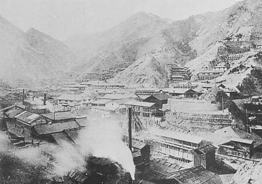
[88] Joanna L. Dyl, Seismic City: An Environmental History of San Francisco’s 1906 Earthquake, University of Washington Press, Seattle, 2017, Chapters 2 and 4
[89] Joanna L. Dyl, ibid., p. 20.
The main difference between a technological disaster and a geological disaster exacerbated by human factors is the random factor brought by the geological risk. Even with the most performant detection tools, seismic prevention actors struggle to determine precisely when an earthquake would occur. It is rather a period of probability when the earthquake is the most likely to happen.
In the case of an earthquake, the environmental injustice could be found to be tied to the social geography and economy of a stricken area. In fact, a seismic tremor is most destructive in areas with structurally poor, badly maintained architecture and a difficulty of circulation due to infrastructures. Additionally, political factors are another complicating factor due to the choices made by different actors in their gestion of private and collective space. Depending on the legislation of the marginalization of certain groups of people, on the architectural codes and finally on the emergency planning of the given community, the result may vary wildly.
Let’s take the example of a crossing between seismicity and human factors outside of Japan with the 1906 San Francisco earthquake. Before the earthquake, the city experienced multiple earthquakes without taking this risk seriously into consideration. Moreover, the Gold Rush and transpacific migrations significantly increased the population, above the capacity of absorption of the city. This rapid population boom led to the conditions for an organic growth of the city and the creation of some shanty towns. At the end of the 19th century, the rising fear of the Yellow Threat rose around the Western World and the Boxer’s Revolt led to a wave xenophobic against the Chinese Americans of San Francisco. It resulted in a special marginalization and precarisation of their living spaces[88].
Based on the work of Johanna Dyl, the total toll of the 1906 San Francisco earthquake counted only the white victims at first and omitted the non-white ones, despite numbers being roughly the same. The high toll of the racialized victims could be explained by the poor maintenance of the buildings, notably the ones where the Chinese community was inhabiting[89]. The racial bias against the Chinese-American communities of unsanitariness came from the fact that these very people lived in marginalized spaces and lower quality infrastructures. Blaming socio-economic inequality on cultural factors in other words. In colonial societies, the racial factor will be a supplementary variable worsening the already most vulnerable parts of those societies.
Ultimately, the cases of Taiwan, Manchuria, Japan and San Francisco collectively reveal a common pattern: colonial and imperial systems systematically produced structural vulnerabilities that magnified the human cost of natural or technological hazards. By displacing resources, undermining local social structures, and privileging the interests of metropolitan or elite groups, these regimes reduced the adaptive capacity of the populations most exposed to risk. This dynamic—what scholars of environmental justice describe as the unequal distribution of environmental harms and protections—demonstrates that disasters are rarely “natural”[90]. They are shaped by political choices, economic hierarchies, and racialized power relations. Reintegrating this understanding into contemporary disaster mitigation frameworks is essential. Only by acknowledging how these historical inequalities were produced, and by correcting the asymmetries of power and resources that persist today, can societies hope to build genuinely resilient and environmentally just systems for the communities most at risk.
[90] Susannah M. Hoffman, Anthony Oliver-Smith (eds.), Catastrophe & Culture: the Anthropology of Disaster, School of American Research Press ; J. Currey, Santa Fe, NM : Oxford, 2002, pp. 23-48.
[91] Government-General of Taiwan, Report on the Earthquake of Year 10 of Shōwa-era, Government-General of Taiwan, Taipei, 1936.
[92] Gennifer Weisenfeld, op. cit., pp. 282-283.
Conclusion
After having seen the deep changes brought by the Meishan earthquake on the Chiayi region and the fact that the Japanese colonial government took advantage of the earthquake to strengthen its grip over the area, after a first period of colonial pacification wars, we may conclude that this earthquake in colonial situation had a mixed impact on the location. On one hand, the catastrophe brought further loss to the autonomy of the local population of Taiwan in profit of the Japanese settlers and colonizers. On the other hand, the aftermath allowed to put in place infrastructures in the region that economically dynamized the region.
In 1935, a second, even stronger earthquake struck central Taiwan. Then Japanese control over Taiwan and the area was at its height. In a span of 29 years, did the region and local administrators learn the lessons of 1906 and implement local measures to the peculiar case ?[91] Nonetheless, one must not forget as well that the 1923 Great Kantō Earthquake is still imprinted in the recent memories of the time. Two years prior, a grand festivity to commemorate the renaissance of Tokyo, having seemingly risen from its ashes[92].
From afar, the previous experiences from the earthquake throughout the Empire seemed to have been useful to the authorities. The immediate aftermath of the disaster mobilized a wide variety of actors, participating collectively and concertedly to the rescue and subsequent reconstruction efforts. The local Taiwanese society seemed to have been more vocal about the earthquake as well, compared to the local archives of the 1906 seismic disaster.
A lot of research has still to be done for a better comprehension of the interaction between seismicity and coloniality, more broadly of natural disasters in a colonial context. The book of Mike Davis could give us a glimpse of the dramatic effects of colonial negligence of European colonial powers and climatic phenomena such as El Niño.